Test of Android version 5.5.x
-
234 Comments sorted by
-
Hi Tomas,String.xml - Crowdin - French version 6.0.xx Ok.
-
I would really appreciate a reply of any sort from the Mapfactor team.
-
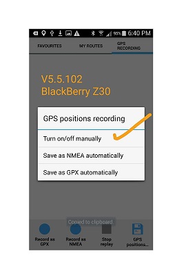
turn on/aff manually is not needed - it is there when auto is not Onwhen I set record NMEA automatically I get NMEAwhen I set record GPX automatically I get GPXmay be someone else can try it?
-
Hi,
On version 5.5.103 arm64-v8a:
when I choose NMEA recording, I get NMEA
when I choose GPX recording, I get GPX
But the save position function on the right does not work.
-
@tomasIn my case when I set "record GPX automatically" I do not get GPX. I get NMEA record automatically.When I set "record NMEA automatically " I do not get NMEA instead I get the options "record as gpx" and "record as nmea" options at bottom of the screen light up. If I choose none of them then no recording takes place. In effect it behaves as the now missing option "Turn on/off manually".The only automatic recordings i get now are in NMEA format.@MacDony - do you see the files saved as gpx or nmea. They are saved after navigation is activated.Also if "turn on/aff manually is not needed - it is there when auto is not On" how do you set Auto On or Off?.
-
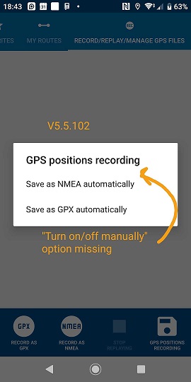
@tomasTomas, some questions to you to help me understand what is going on.1. following your statement "turn on/aff manually is not needed - it is there when auto is not On" how do I record manually? Used to record rides without having set a destination. My default is to record GPX automatically which I cannot set now.2. After you set "record NMEA automatically" and "set record GPX automatically" do you run a navigation, ie set a destination, start navigation and end navigation and thus creating the file?3. Which screenshot to you get on your device. Left is from my BB Z30 and right from my Sony xperia xz2
-
1. click the diskette icon, bottom right2. yes3. right
-
@tomas - Thanks TomasI am now confident that there is something wrong on mine. Please download and watch the video...Started with a clean, with no gps records recorded.Set to Save as GPX automatically1 - note GPX and NMEA left bottom are greyed out2 - start navigation, recording flashing, stop navigation, check file3 - result NMEA file recorded.Set to Save as NMEA automatically1 - note GPX and NMEA left bottom are activated now2 - Manual GPX and NMEA works as expected ie start and stopBut how do I set Save as GPX automatically?
-
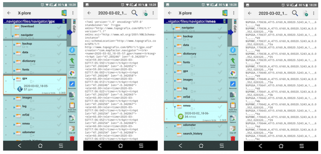
@MacDony - do you see the files saved as gpx or nmea. They are saved after navigation is activated.Blackview 6800Pro - in 64 bits version 5.5.103 arm64-v8a - Yes.... Gpx and NmeaYotaphone 2 - in 32 bits version 5.5.103 armeabi-v7a - Yes.... Gpx and Nmea
-
5.5.105- missing newly added favorites in backup on Google drive fix- TomTom Mexico fix
-
@Stepan
Please save this Navigation.xml file for the next update.
Modifications of the French part.
Download link:
deleted...
Thx.
-
Bug: Change of phone's TTS engine recognized only after TTS language change.I've switched to a new Samsung recently. When you set up Navigator, the default voice is a recorded voice. So I switched to TTS, which by default was a Samsung TTS engine. Did not like it. I updated my phone's default TTS engine to Google, then updated the Navigator settings (Google was really displayed) - and was still entertained by Samsung TTS. Restarting, switching back and forth ... Samsung TTS was still played, despite Google being displayed.However, I was finally able to hear Google TTS by doing exactly this:In the Navigator settings, where TTS is already enabled, choose another lange (I needed DE, but chose GB instead), close. Open settings again, switch to DE - et voilà.Could you please fix that?
-
@chattiewoman OK, thanks for the bug report
-
@Stepan
Please add this file Navigation.xml for the next update : French part.
You can download it on my Google Drive here:
https://drive.google.com/open?id=1H2A1NRhStDzY6hHd7AshO8vlSwJmDWsx
I deleted the unnecessary comments (French part) in the last link.
Many thanks.
-
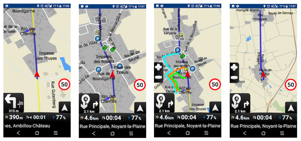
Hi,Version 5.5.107Default car profile.Navigator does not take Street type segments into account for route recalculation.For example, I cannot or forgot to turn left to reach my destination 390 meters away.However, I have 3 possibilities of Green, Orange and Blue routes.Navigator will turn around at the roundabout at 2 km and extend the course by 4 km instead of about 400 meters.In pictures:
-
4 km only? That is nothing. If you look here, it may some hundreds km.
-
Hi Oldie,
Your problem may also be that the calculation does not take enough Street type in the last km ..... like me -
@MacDony: Do you also have "small local roads" switched on?To me that is the biggest mis-configuration of Navigator leading to these kind of sometimes complete wrong detours.By default it is switched off. It should be on by default, maybe with a slightly lower priority than 50, say 45.Sometimes, also on long routes, you need to pass a smaller road. If it is not allowed, you get again a sometimes huge detour.
-
Hi Hvdwolf,
Default car profile.
"small local roads" switched off.
There is no "small local road" in the streets blue orange green color
These are "street" type segments with no restrictions.
-
Please switch "small local roads" on.Most roads in Noyant-la-Plaine in your screen capture are "small local roads" (residential/alley/etc) apart from the D70E/Rue Principale and the "Route Martigné Briand".So again: Please switch "small local roads" on, and try again.
-
Yes, you're right, with 35% of small local road it works.
below it doesn't work properly (34%)
But this is not normal in my humble opinion. -
In my case, it is probably something else. There was a traffice jam at the autobahn, when I was on my way to Dresden, some 30 km ahead. So I switched of the autobahn option and thought, Navigator would leave the autobahn at the next exit. But Navigator went on on the Autobahn not straight to Schwerin (more than 400 km northwest of Dresden, made somehow a u-turn there, went back on the Autobahn to near Berlin and used other roads only from somewhere before Berlin Down to Dresden. 800km + rather than 30 or 40km ...
:-)) -
Hi,Version 5.5.107When I put 3 fingers on the menu, the menu icons disappear.But they are active.

-
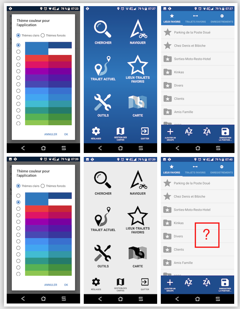
Hi,Version 5.5.107Bug in customizing the application
-
@MacDony: Why not put the small local roads on 45% (that is my setting). They will not be chosen anyway if a faster route is available.But on the other side: You might get really weird detours when disabled.Even more: we had several (many) posts here where users could not reach their destination because they had to use a small local road, and those are switched off by default.. This is mostly at the end when you reach your destination (or want to reach your destination): a house address, a camping at the end of a small road, a parking place "somewhere" in nature at the end of a small road, access to a ferry ramp, etc. etc.@Mapfactor: How does the GPX/NMEA recording work? Only for navigation?It used to work also when navigation was switched off. Sometimes you are just walking/hiking or cycling "somewhere", and want to record your track. I don't seem to be able to do that anymore.Please tell me I am doing something wrong (because that means it still works ;) )
-
you can record with or without navigation
-
How? The buttons remain grey.
-
then, I think, gpx or nmea folder does not existplease check that
-
GPS position recording was perfect with the 3 options available but someone decided to "fix" it.
I cannot set it to save automatically in gpx format.
I have given up pointing it out... -
you still have three options, manual is default when automatic is not setit works fine for me
-
I checked again and I can see that there is a problem (bug)when switched to record GPX automatically then manual switch is greyed outwe will fix thatin the meantime switch to Auto NMEA, then button for manual recording will be active
-
confirmed
-
AT LAST!Just put it back the way it was. It was simple and easy to understand and follow and... it was working fine.Please note that in my case choosing GPX Automatically it saves the file in NMEA format and not GPX.( for further details please see my previous comments and video posted in this thread )
-
Hi Hvdwolf,
Now my settings are with Local Roads at 35%.
Howdy, Stranger!
It looks like you're new here. If you want to get involved, click one of these buttons!
Categories
- All Discussions3,266
- Feature Requests1,276
- Bugs559
- General378
- Navigator FREE1,031
- Vehicle Tracking5
- Navigator 1017
In this Discussion
- 2highlander January 2020
- chattiewoman March 2020
- daveR July 2019
- Delfin February 2020
- hvdwolf March 2020
- JambaFee August 2019
- jd417 July 2019
- MacDony March 2020
- MalaFili August 2019
- Matthias November 2019
- MiraS July 2019
- NannTrugarez February 2020
- Oldie March 2020
- rab September 2019
- Roldorf August 2019
- Siggi January 2020
- stavrich March 2020
- stepan March 2020
- tomas March 2020
- user_mf August 2019