Serious routing error
-
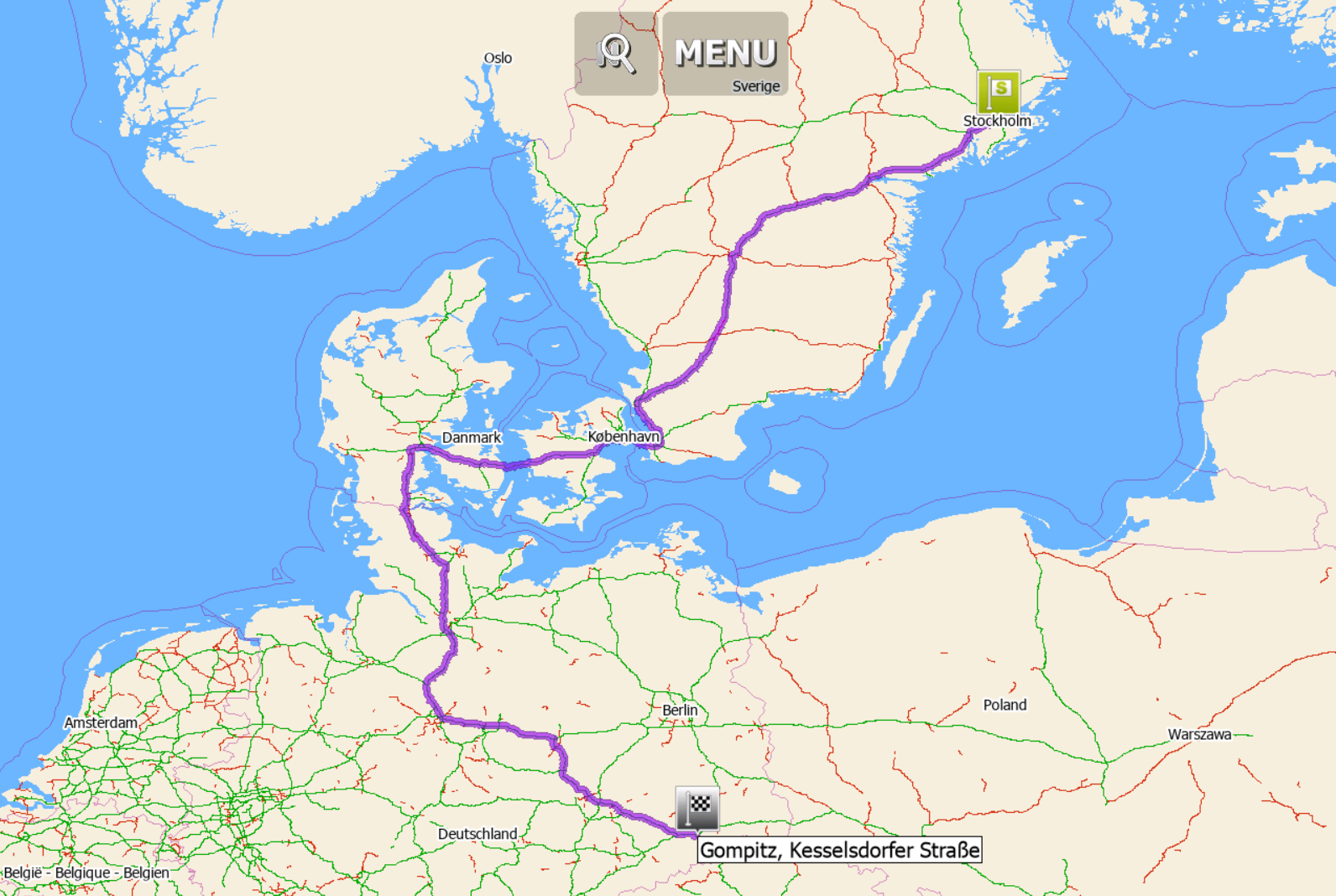
Stockholm (59.324833, 18.070417) --> Dresden-Gompitz (51.040500, 13.645278): 1609 km, 13:28:13 h
 Stockholm (59.324833, 18.070417) --> Dresden-Cotta (51.056667, 13.666972): 1280 km, 12:08:02 h
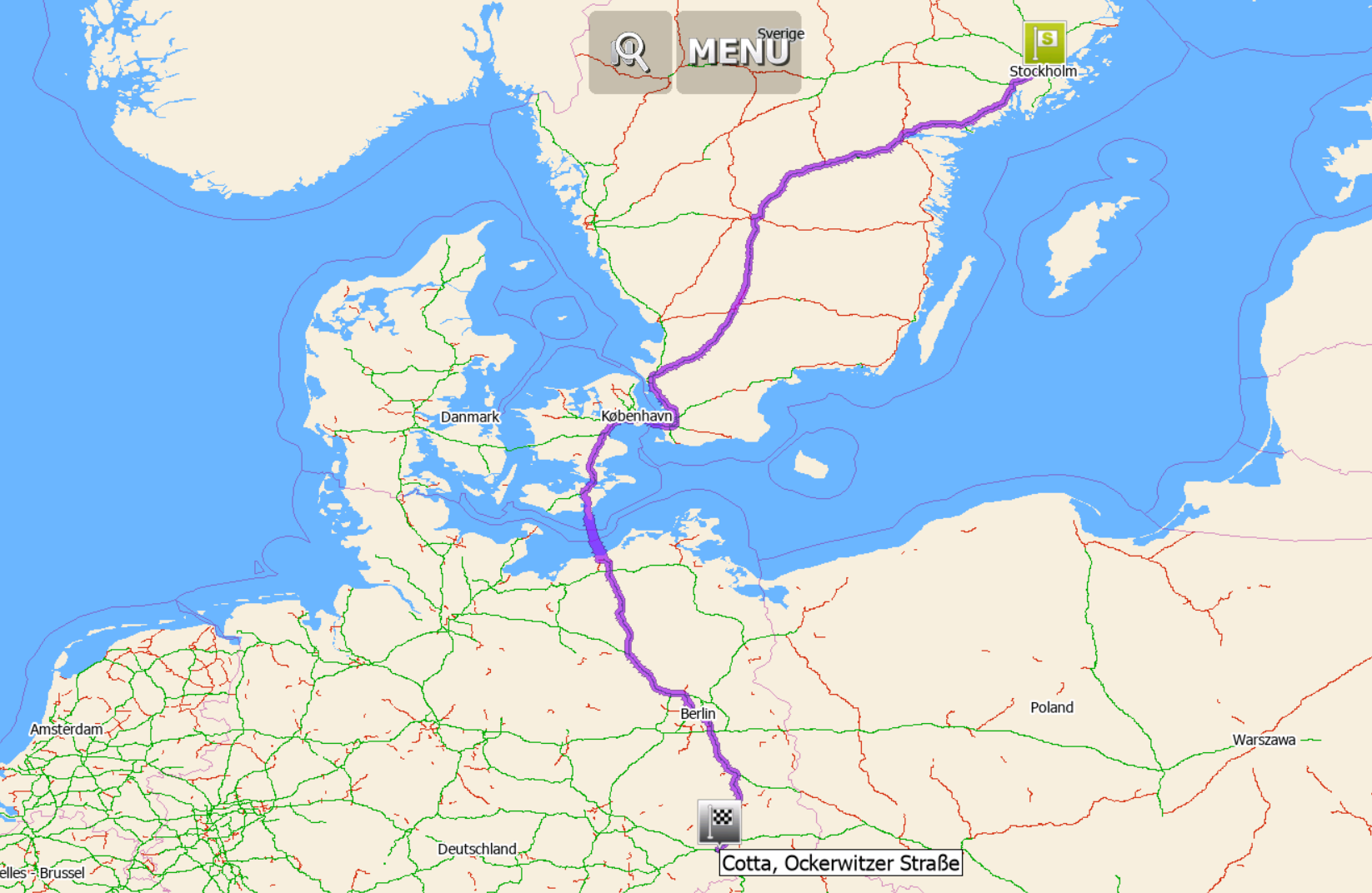 A difference of 329 km, although the starting point is the same and the destinations are only 3.5 km apart.Settings: default car, fastest route.
 -
16 Comments sorted by
-
with default car settings I getfirst route - 1293km, 12h 38msecond route - 1281km 12h 9mplease check your vehicle settings
-
Mapfactor routes sometimes really are surprising.
-
There have been a lot of questions about bad routing in MFN and everytime tomas answers these questions like here, implying the opinion that the mistake lies with the questioner.
I don't know why he does it because in this thread (among others) he already answered (after a long hesitiation) a similiar question mentioning hidden options that are responsible for the bad routing.
-
I try route with default settings and give results, nothing less, nothing moreI cannot analyse route calculation wih every vehicle settings user may set - that is beyond anybody's capabilities, sorry
-
with or without ferries in the settings?First route is only taking bridges.Second route is taking the ferry from Falster to Rostock.In this case I agree with Tomas: Check your settings.
-
I understand both of you. Sometimes I also do not understand MFN's routing. But in many cases the routing surprises me on a positive way and a I find, that makes really sense. Since the app is free, I think we should be patient with the producer. And with @Tomas, who is the buffer between users and the mapfactor company, what often results as an unfortunate task.
-
As stated in the first post, the default settings were used. Since Tomas tests with the default settings, he should get the same values for the distances and times to destination. This is not the case and it is not the first time. Does he use other software or maps than we do?
-
I get the no ferry route only when I set the option for a choice of routes. So there seems to be something in Navigator, which means, that that may be a valuable alternative.Because for me, one or two of those alternatives regularly do make no sense at all, I do generally not use the choice option.
-
I used the same settings (default car) for both routeslatest OSM mapsif you do not believe me, then I have nothing to add
-
tomas, the routing example in the first post was made with the PC-version of MFN, you compare it with the Android-version, that's your first mistake.
If you would have tried a clean install with only deafult values you would have gotten exactly the same results as Delfin in his first post - that's your second mistake. If you had read carefully read my first post in this thread you would have read the post I linked to (https://forum.mapfactor.com/discussion/8879/severe-error-with-small-local-road-enabled#Item_5). There you yourself describe what's the cause of such totally silly routings. That's your third mistake.
So from now on I am talking only about the PC-version. In the PC-version of MFN the method you described to enter new limit values doesn't work. On PC you have to enter the new value(s) manually in the file "truck_restrictions.xml" (in a folder similiar to C:\Users\tomas\AppData\Roaming\Navigator\19.1). The value that's required to get a correct result for Delfin's route is just this one:
<limit_meters>800000</limit_meters>
This line has to be entered (according to xml-syntax) anywhere in the settings of the "car"-definition. Any value below 786 km isn't enough (in this case).
-
Hi Jamba Fee.I think that you are being rather harsh on Tomas.You seem to be bullying him for not knowing details of platforms which have not been stated.Tomas is an excelent help desk guy with in depth experience in Navigatior and with problem solving.I have known Tomas for many many years as a customer of Mapfactor and have always found him courtious and competent.Pehaps you could be less confrontational and hopefully apologise to Tomas for the tone of your comment.This is my personal opinion.I would have taten a pragmatic aproach. The application gives you three routes to chose from. Choose the one closest to the route you want. If it is still not the route you like then use waypoints. In the case hear put a waypoint on the bridge of choise.
-
this seems to be error in free maps, it is fine with TomTom
-
Hi,The problem is OSM ?!When I put the coordinates on OSM there is no problem .....
-
I think the problem is that road is not split at borderwe process data by country and small piece is missing in NetherlandOSM server would not have this problem, they do not split by countryplease note, that is my theory, I am not expert on OSM maps
-
The App Magic Earth has no issue at this border crossing and is also working with OSM. For me this isn't a problem I know this area quite well and don't need a navigation program there.
Howdy, Stranger!
It looks like you're new here. If you want to get involved, click one of these buttons!
Categories
- All Discussions3,266
- Feature Requests1,276
- Bugs559
- General378
- Navigator FREE1,031
- Vehicle Tracking5
- Navigator 1017