Severe error with “small local road” enabled
-
Routing from 47.82366667, 15.12866667 to 46.7577368, 15.96274687 with following options:
Fastest route
default car profile, "primary road", "major road", "secondary road", "local connecting road", "local road of high importance", "local road" and "small local road" enabled, all the rest is disabled:
PC: 299 km, 04:31:07
Android: 299 km, 04:31
With "small local roads" disabled the result is:
PC: 200 km, 03:07:13
Android: 205 km, 03:07
That’s on both platforms an inacceptable detour of almost 100 km (50 %) and 1,5 hours (45 %) when "small local road" is enabled.
This error already has been described
here ==> https://forum.mapfactor.com/discussion/8143/ (Aug 2017) and
here ==> https://forum.mapfactor.com/discussion/8807/ (May 2019) and maybe on other places.
It is obvious that this is a serious error in route calculation and it’s unbelievable that such a major bug is already known a few years and there is neither a reaction of Mapfactor nor a bug fix.
-
28 Comments sorted by
-
with default car settings I get 211km with small local roads disabled and 222km with small local roads enabledwith TomTo it is 220km and 224km respectivelyI would say that you made some other changes
-
Dear tomas,
today I installed MFN on a PC as well as on an Android device where there never have been any MFN installations to be sure to have untouched configurations. The result:
"small local road" enabled:
PC: 294 km, 04:28:54
Android: 299 km, 04:31
"small local road" disabled:
PC: 200 km, 03:07:13
Android: 205 km, 03:07
So
1) Maybe Tomas your configuration is different from standard?
2) Maybe someone else could check the results on her/his installation?
3) Any other ideas what I could have done wrong with my implementations?
"small local road" enabled: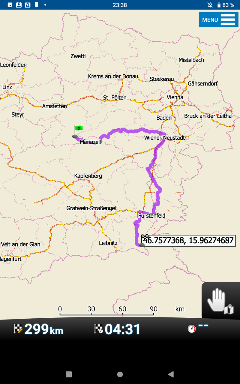
"small local road" disabled: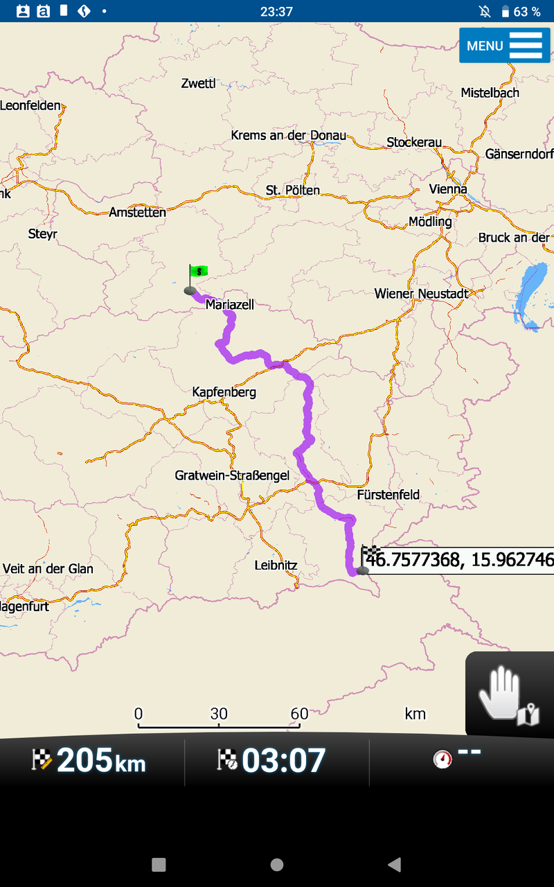
car settings: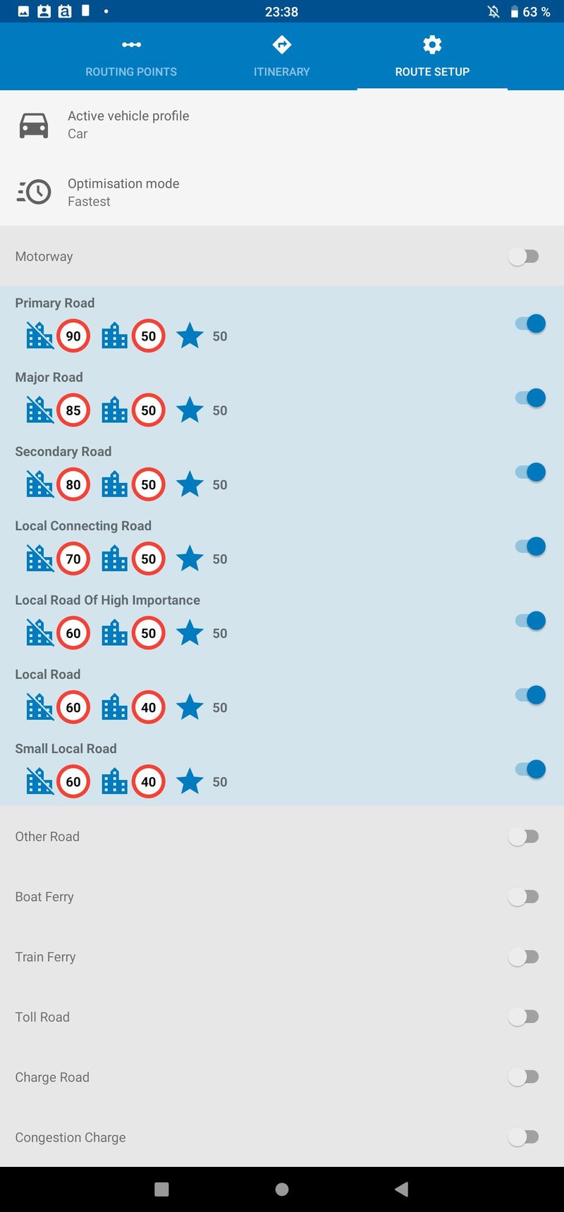
-
I get exactly the same results as JambaFee.
-
I reset vehicle profiles to default, now I get 204km without small local roads and 203km withbut I noticed that JambaFee has also disabled motorways, which I missed in his first postthis is not bug, it is part of hidden settings to make calculation/recalculation fast as mobile devices have limited recoursesto unlock these hidden settings go to settings/vehicle profiles and press screen for 20s - please remember, higher numbers mean slower calculation
-
@tomas
What exactly do you press and on which screen? I've not managed to find it. -
Just somewhere in the white wild. You will get an additional menu in the upper right corner "Erweitert" (in Englisch probably "Extended" or the like). Tapping this you get this screen, which is not self explanatory for me:

-
top part is for overall settings, bottom part with motorways offexpansion limit is how many links routing uses around departure/destination/waypoint, distance is in meters from departure/destination/waypointonce these limits are reached, only transit network is used (mostly motorways)for example, driving from a to b without motorways, where distance is higher then 2x250km you will need to extend distance (bottom half) to more then 250000 and probably also expansion limit, possibly to 500000 (this really depends where it is - urban areas have more links then rural)remember, higher numbers mean slower computation
-
May be, this is the same issue as here: https://forum.mapfactor.com/discussion/8874/oh-no#Item_17? Only that Navigator makes 800km+ for just 3,5km there?
-
probably not
-
Do I interpret this menu right? Is this an indirect option to determine how 'curvy' navigation is...?
-
Resetting the values in the extended menue with the relevant button does not restore the values as they had been before any change had been made. Expansion limit above is reduced.Data in the lower section will be the same as they are in the above section, not just "not set".
-
I assume it has to do with the A* algorithm and the "shortest path" determination. And in this case a limitation in the number of paths to check.
-
-
What are the default settings?The ones I found, when I first entered the menu?Or the ones I have now after tapping the reset button?The values are definitely different!
-
This is default after first opening of the menue (on my phone):
 And this is default after resetting (on my tablet):
-
when you click reset you will get default valuesvalues are rembered until you change them
-
@Tomas
With curvy I mean whether navigation will head on as straight as possible or preferring curves. These settings could be interesting for bikers. -
@oldie
When resetting, my installation reacts exactly like Yours on both phones s5 and s9+ -
no, it is not for scenic routesif you start with default vehicle settings and go to advanced, then you will all values marked as Not set, not what you see in Oldie's first screenshot
-
So when does Navigator change the values to those I found in the above sections? It is for sure, that I did not change them manually!
-
you could have done by editing vehicle_profiles.xmlthere is no other explanationyou can try to delete it, start Navigator and go to advanced settings
-
Tomas, definitely no. When fiddling around in the wild area, there is no hint that the parameters in the advanced menu belong to a certain profile. Me thinks these are common parameters for all profiles.
First section shows 100.000, 250.000 m, 60 km/h, second section all 3 parameters show 'not set' when having opened advanced menu for the first time. After tapping the reset button all fields of both sections show the same numbers as seen on oldie's 2nd screenshot and these numbers are kept after having closed and opened the expansion menu again.
I have some additional profiles running but never edited vehicles.xml manually.
Resetting doesn't seem to hurt though. I played around a bit after resetting and didn't notice any difference. -
did you delete file vehicle_profiles.xml?
-
Errr, no. Why should I?
-
to see that what I say is what it shows
-
On my clean installation the extended option at the first call looks like this:
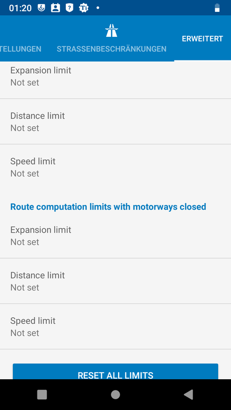
After hitting “reset all limits”: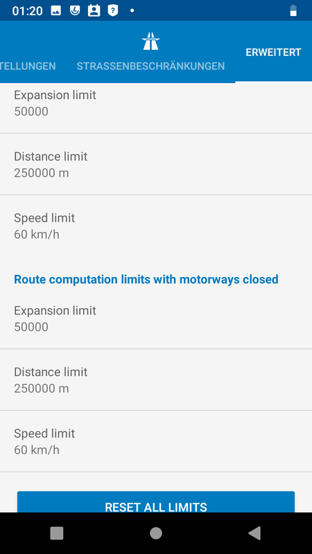
When changing values for a certain profile there’s no matter what profile I activate then, the extended values always seem to be the one that were changed last. But when looking at the file "vehicle_profiles.xml" the values are indeed set correctly. So it looks as if this extended function is not implemented correctly. The question is, if the values from the extended display are used for calculation or the ones from vehicle_profiles.xml.
I have changed my daily used profiles to the values expansion limit = 500000 and distance limit to 1000 km and with this settings at least the route from my first post is calculated correctly. Calculation time is recognisable longer but still acceptable and is worth the fact that in this way I get the right route. Wrong route calculation, especially when causing a detour of 50 %, is a total No-Go.
It would be interesting if there is a way to find out how many links are used for a calculation to have an idea of how to set the expansion limit value.
-
firstly distance is from each waypoint, so 1000km journey ith departure and destination only needs just 500000 in distance settings (may be a little more just to make sure)changed values are written to vehicle_profiles.xml, please look at sections <limit_meters> and <limit_expansion>
-
I use MFN for biking. Especially when having small city roads switched off, I sometimes had very odd route calculations. As a consequence, I never switch off roads I do NOT want to drive completely but pull the priority value down to 10 or 1. Done so with highways and small city roads for example.
Howdy, Stranger!
It looks like you're new here. If you want to get involved, click one of these buttons!
Categories
- All Discussions3,264
- Feature Requests1,275
- Bugs558
- General378
- Navigator FREE1,031
- Vehicle Tracking5
- Navigator 1017
In this Discussion
- 2highlander August 2019
- Delfin August 2019
- hvdwolf August 2019
- JambaFee August 2019
- john_percy August 2019
- Oldie August 2019
- tomas August 2019