Getting around with a .GPX
-
Hello,
Biker, I have been using Navigator for 6 months and I am generally satisfied with it. Organizing outings with a club, I have to plot programmed routes and I get a GPX track.
I have found how to import this track into the application, I see it on the map but I have not found how to trigger navigation on this track. !!
Can you tell me how to start a .GPX route on navigator?Thank you very much and good day.ChristianFrance - Lyon -
25 Comments sorted by
-
if GPX file contains waypoints (wpt), then it is imported as routing points set and you can use it to navigate if it conatins trackpoints (trkpt), then it is imported as track - you would need to display track on the map and create waypoints along
it is quite well explained here
https://en.wikipedia.org/wiki/GPS_Exchange_Format
-
Hello Tomas,
What you are telling me corresponds to what I have read on the few answers to this question asked since at least 2015 and which still does not have a satisfactory answer I think.
It is, in my opinion of geographer, (IGN-1977/1980) much too complicated for the majority of the users to proceed as you indicate to me. It is too long and not understandable for many. This is really a shame for your application which offers a good comfort of use while one of its immediate competitors, Osmand + for which I worked a little in my spare time, offers the import of GPX trace de facto and whatever the converter used to go from .KLM to .GPX or with native .GPX created with OSRM or OpenRoute Service.
It's a shame and for me who uses GPX a lot (and I'm not the only one) it's a definite handicap.
I hope someone at Mapfactor takes this question seriously one of these days and comes up with a reliable and easy solution to import .GPX so that Navigator is on top.Thank you for your super fast response and have a nice day.ChristianFR / AN Google translation !!! -
Salut Christian,Pas de soucis, Navigator importe bien les fichiers Gpx.J'utilise des fichiers Gpx depuis plusieurs années....Tu as dû mettre ton fichier dans le dossier "Gpx" de Navigator et tu as uniquement un visuel du tracé, inexploitable, je suppose.Tu fais comme ça :Je suppose que tes fichiers Gpx sont de type "rte"ou "wpt"Tu dois recevoir tes fichiers par mail, enfin peu importe.Tu places ton fichier dans le dossier Download de ton smartphone (par exemple)Avec un explorateur de fichier, perso j'utilise X-plore car celui de base ne le permettait pas,tu vas dans ton dossier download, tu cliques sur ton fichier,ton explorateur va te proposer "ouvrir avec Osmand ou Navigator", si tu n'as pas mis "Toujours" pour osmandtu cliques sur Navigator et ensuite tu auras une fenêtre qui te demandera si tu veux importer le fichier Gpx.(avec X-plore, tu cliques sur "*/*" et ensuite tu auras le choix)Ok et ton fichier sera dans tes Favoris dans l'onglet "Trajets Favoris"Tu pourras ensuite cliquer sur ton Trajet Favoris, charger, tu auras la liste de tes points de passage.ensuite tu fais Naviguer ou montrer sur la carte.Voilà, voilà ;)Si tu as un soucis, tu me le dis ;)Denis.
-
I am not sure what is it that you expect from usA route is a sequence of waypoints, its the plan for your navigation. A
track is the recorded path you did actually follow while trying to
implement the plan (the route).there are converters on Google Play you can use -
Hi Christian,you can NOT "run a GPX file".You need to import it to Navigator, as shown here (example):Before import make sure it's waypoint file not a route...Markus
-
Bonjour Mac Dony, and the other of course.Ça fait du bien de causer en "françois" . Ne maîtrisant pas bien l'"anglois" c'est mieux.En fait, j'ai bien fait tout ce que tu écris jusqu'à :"Ok et ton fichier sera dans tes Favoris dans l'onglet "Trajets Favoris"". Le mien, il n'arrive pas dans Trajets favoris mais dans "Enregistrements" !!! et à partir de là je ne peux que le regarder béatement mais point naviguer:Ce qui me chagrine c'est que je ne vois pas trop ce qu'est un fichier "waypoint" par rapport à un .GPX "classique".Je fais mes GPX depuis des années avec soit MyMaps en .klm transformé en .GPX par un utilitaire quelconque ou avec ORSM et ou OpenRoute Service (très bon) qui me sort un GPX tout fait.Je ne voudrai pas en rajouter une couche sur Osmand+ que j'utilise depuis longtemps et qui prend tous les GPX qu'on lui donne sans arrières pensées.Merci pour ton aide et si c'est possible explique moi cette affaire de "waypoint" et comment y arriver et pourquoi Navigator refuse les GPX classiques.Christian
-
are you sure that Osmand navigates GPS track?to my knowledge it simply navigates to the last trackpoint ignoring all othersif that is what you want you can do that with Navigator as well
-
Hello Markus.
Thank you for your post which corresponds to what I have been reading for a few days on Navigator, but I don't see the difference between a .GPX waypoint and a .GPX from OSRM or OpenRoute Service or any other utility transforming klm into. GPX?
All I see is that the navigator cannot turn a classic .GPX into a route and start a route. Again, I don't want to lather Osmand + but it does it natively and I don't understand why Navigator which has enormous qualities does not do it.
In my motorcycle club I try to get the guys to Navigator. For a classic trip no problem but for a programmed circuit it is impossible for the moment. Return to Waze or Osmand.
Thank you
Christian
PS: For Tomas, I can't find Route Importer in the Google Play store. Neither by design nor by name !! Thank you -
it is a third party app, it may have been removed
-
Hello Tomas,I have been using Osmand + for years, whether for defined routes "Departure, arrival" or by importing a .GPX from, as I said, a .klm from MyMaps translated into .GPX or best of OpenRout Service which does it natively.You can see that the second image is a defined route; Departure Arrival.
Once the GPX imported, Osmand presents image 1 then click on Trace, then: back then Favorites and it appears in Traces. Back, Navigation Tracks displayed, Start.
And on the way. It's that simple.
Thank you and good day.
Christian -
Salut Christian,
Je pense que ton fichier est une "trace"
si tu peux me l'envoyer par mail, j'y regarderai et je te dirai ;
macdony49 arobase et gmail et point com.
-
Ha oui, si tu y arrive avec osmand,
tu affiche ton trajet et tu cliques sur partager
puis tu l'enregistres dans ton dossier téléchargements
puis tu cliques sur le fichier et là ça devrait fonctionner.
je viens de faire le test et c'est bon chez moi.
;)
-
I also think it is a trackyou can replay track with Navigator
-
I don't understand the problem. You have just to make sure that the gpx You have created is NOT a track or a waypoint list, but a route. Then tap on it, select open with MFN and an import dialogue appears. When You're done MFN will inform You that the imported route will be found at my places/my routes. Just load it and off You go ...
-
Pour en revenir à ta demande sur
"Ce qui me chagrine c'est que je ne vois pas trop ce qu'est un fichier "waypoint" par rapport à un .GPX "classique"."
il y a 3 types de fichiers Gpx et non pas un Gpx classique.
- le Gpx de type waypoints <wpt>, qui comporte les coordonnées et nom des membres du Club, tes favoris...
- le Gpx de type route <rte>, qui contient les points de passage d'un itinéraire, en gros 1 point toutes les 10 bornes, le Gps calcul le trajet entre ses points
- le Gpx de type trace <trk>, qui sont généralement un enregistrement de ton trajet et qui comporte un point tout les 100 mètres ou plus ou moins.... les fichiers sont volumineux.
Si tu ouvre ton fichier avec un éditeur de texte, tu verras le type de Gpx que tu as.
voilà, voilà....
Tiens, un lien au cas où je ne suis pas clair :
http://www.bel-horizon.eu/la-cartographie/la-boite-a-outils/trace-route-waypoint/les-fichiers-gpx.html
;)
-
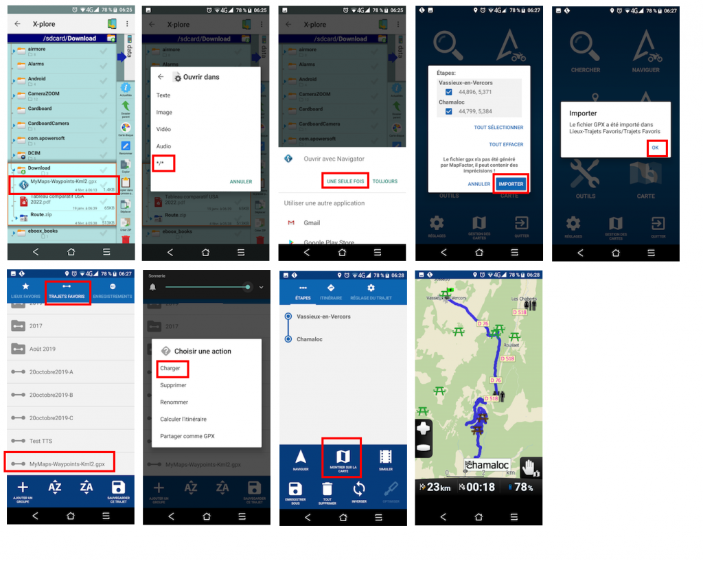
Bonjour Christian,Le fichier converti Kml2gpx waypoints(uniquement) fonctionne très bien avec Navigator.Tu mets le fichier dans un dossier, tu cliques dessus et ça l'ouvre avec Navigator.tu cliques sur importer, ok et il est dans tes trajets favoris.Mais je pense que vous vous compliquez la vie pour créer vos trajets.En image :
-
To find out the format of your GPX file, you can use ITNConv or RouteConverter.Open the file and it (mostly) shows the format and let you export it as waypoint file.Markus
-
Bonjour Christian,Tu me dis "je me suis retrouvé avec une carte pleine de petits drapeaux rouges"Attention !!Le fait de convertir un Kml en Gpx(trk) puis le Gpx(trk) en Gpx(wpt) va convertir tout les points(trk) en "étape"C'est à dire que ton trajet va contenir une multitude d'annonces vocalescomme "vous êtes à 100 m de votre étape" puis "étape atteinte" puis vous êtes à 100 m de votre étape" puis "étape atteinte" etc...Grosse galère en perspective...... une annonce tout les 100 mètres :)De plus, là où ça va être le plus sympa, si pour une raison géographique(en forêt) ou autre, le Gps ne capte plus ta position et qu'un seul de ces points n'a pas été validé comme "point passé"Le Gps te détournera de ton itinéraire pour absolument te faire passer par ce point et ça avec n'importe quel Gps.C'est pourquoi il est préférable de faire un itinéraire à partir d'un programme de carte qui converti le trajet directement en Gpx(wpt) ou Gpx(rte) que tout Gps interprète très bien, surtout Gpx(rte)Pour ça, il y a Kurviger qui permet la création d'itinéraires et l'export GPX dans les 3 choix : trk - wpt - rteLe lien :J'ai fais des vidéos, il y a 2 ou 3 ans, pour utiliser kurviger ici :et comment exporter en Gpx(rte) ici :Ou faire ton itinéraire à partir de l'application Navigator, ce que perso je fais à chaque fois et c'est très rapide ;)Voilà, voilà....Denis.
-
Hello,
I come back to you all to tell you that finally I managed to send a GPX route to Navigator.
Thanks to MacDony who helped me a lot on this one.
End of the adventure. All that remains is to take the full-scale test over the 5 days of walks.
I do not know if there are people from Mapfactor who read these posts, I think so and I would like to send them two comments on navigation.
They are both linked to comments heard during the trip. For the rest it is very good.
1- Instructions like "2 km turn right" are excessive because how do we know when we will have done these two kilometers. This morning I even heard "In 4 Kilometers turn left" Wow. What a memory you have to have !! I think from experience that the maximum should not exceed 500 meters.
2- If for any reason we leave the route, a charming lady tells us "We are recalculating your route".
Once it's good, 10 times in a row it's unbearable. So I disabled "Recalculate route" and it's a shame.
The simple word "Recalculate" would be more than enough for our modest understanding.
Thank you -
1. we do not have 4km announcement, who knows what you heard :-)2km are usually used on motorways when you go fast2. not sure what to say, I think it is an important announcement
-
Hello tomas,Let's put that 4 km ....But even 2 km is far too far and I hear it especially on normal roads. That’s for sure.
Then, important information or not, the sentence is unnecessarily too long and it becomes tiring when you are in a compulsory circumvention. I sincerely think that "Recalculation" would be more than enough and we will understand very well what it means.
now if you think everything that Mapfactor is doing is perfect and not criticized, you have to close the forum No? I'm kidding but it's a bit true all the same.
Thank you -
2km announcement is only in high speeds - if you travel say 120km/h then 2km is reached in 30sI do not quite understand why do you get so many announcements, why don't you follow routewe just cannot please everybody all the timeyou can edit file navigation.xml
-
Salut Christian,Tu peux éditer le fichier TTS.xml qui se trouve dans le dossier :Android/data/com.mapfactor.navigator/files/navigator/à peu prêt à 60% du fichier, dans le langage "fr", tu as les lignes :<token>A-OT-03-00</token><text>Nous recalculons votre itinéraire.</text>Tu fais la modif de ce que tu veux ;)Le fichier Navigation.xml se trouve dans le même dossier.Denis.
-
Do backup the file as it will be overwritten each time the app updates.
-
None voice of GPS can please to all people, so the solution is to not have the voice, I allways do that with GPSs
Howdy, Stranger!
It looks like you're new here. If you want to get involved, click one of these buttons!
Categories
- All Discussions3,266
- Feature Requests1,276
- Bugs559
- General378
- Navigator FREE1,031
- Vehicle Tracking5
- Navigator 1017
In this Discussion
- 2highlander February 2020
- Christianv69 February 2020
- john_percy February 2020
- MacDony February 2020
- MalaFili February 2020
- NannTrugarez February 2020
- tomas February 2020