Customize User Interface for use on motobike
-
Hi,like others here, I would like to use MapFactor as Navi for the motorcycle. First tests with a cellphone in the car went quite well.Background is that I am currently using a WinCE GPS with IGo Primo and a special skin, which is excellent for use on a motorcycle.But since these devices don't get any more updates, and this skin is not ported to the Android IGo version, the only thing left for meas a motorcyclist are the too expensive Garmin and TomTom devices, or the still very unstable biker navipps or not usable TomTom Mobile App.Back to Mapfactor, it works very well to import and route the planned waypoints via gpx. What's missing now is a customization of the interface.The following function should be directly on the interface. "delete next waypoint". Currently you have to zoom in on the map and select and delete the waypoint. Of course, this is not possible when riding a motorcycle. Furthermore, an automatic deletion of the waypoints already approached would be helpful. So that one does not start the tour again from the beginning. And the last wish would be, that you can enter a tour at another place, and the routing would then go to the next waypoint and delete the waypoints that came before.Currently I have ordered a 5" GPS with Android 6 from China. With this I will test Mapfactor more intensively on the bike.It would be great if this could be implemented. And I could imagine that some bikers would be happy to pay for it later. I would love to test and support.Best regardsManne
-
18 Comments sorted by
-
you can delete next waypoint from toolbarfirst click map during navigation, then press one tool for 2s and select what you wantwaypoits are deactivated automatically when reached
-
Hi tomas,thank you for the quick response. Yes, that's very good. But if I could take over the point "skip next Waypoint" as link on the map view or in the "change field" area, this would be great. Somtimes I had to skip many points very fast (closed street, save time, change direction...many reasons)BRManne
-
Hi Manne,I'm also using it for motorcycling...It works the way explained, but you had a good idea! Not only for motorcycling.Maybe one of the cracks will be able to change the code in a way we can place the "delete next waypoint"-button directly in the lower end of display if we like.So we could just tap a few times to delete all actually unneeded next waypoint/s.This would be a good point in thinking of secure drive and watch the street not the navi...Markus
-
Yeah, that would be nice. Or maybe there's an option to create a skin yourself in the future.I could imagine that we have 4 POIs to choose from an seperate quickmenu. Just next "gas station" on the route, or cafe, garage etc.I will make a picture / screenshot and modify it accordingly. The other apps like kurviger.de Pro and myrouteapp Navigation are not bad, but they do not treat waypoints the way I want them to be treated.Another idea, if not already mentioned, would be to show the name of the next waypoint, e.g. "refuel"(fuelstop) or "coffee break" (coffeebreak). I always give names for important points. Because, there is no difference between "viapoints" or "shapepoints" like on the Garmin software.I am convinced that this could be a very good app for bikers. Unfortunately, I can't program it myself, but if there was a skin editor, you could get a lot out of it.GreetingsManneTranslated with www.DeepL.com/Translator (free version)
-
-
@cine
Re waypoint label displaying please see some of my posts. I use it on a motorbike as well and as far as I am concerned is much better than the garmin.
I will suggest you become a beta tester and use the beta version. The waypoint name is now been announced.
Skipping missed waypoint. I defined four of the panels as delete waypoint just to make it easier to find -
A year ago I stopped using mapfactor because the screen took a very long time to response when I want to skip a waypoint. When I look at the comments it seems that this behaviour is improved a lot in the last versions.How is this behaviour now???? (i just installed version 5.100)(I defined all eight panels as skip waypoint)
-
Hi,last weekend I did a realtime test with Igo and Mapfactor, and with MyRouteApp Navigation vs. IGo. Igo has a special skin.At the moment Igo is still way ahead of both of them.But we are not giving up.As far as the route calculation is concerned, an option "Easy Route" would really make sense. Stavich has already mentioned this himself somewhere. That's how you torment with your moped through the whole town. With 50-70 waypoints (such a tour through the Dolomites needs a high number of waypoints) a kind of filter would be useful. For example ".wp" is not announced, while "wp" is announced.Could also be a * or a #. That would be great. Then you can have the important points like "refuel", "pee break" or "coffee" announced, and the rest is only for calculation. Also an option for not approaching waypoints could be improved, so that they automatically count as "reached" when they exceed a certain, possibly adjustable, distance. 100, 200, 500, 1000, 2000m.At least almost all roads were found to be "passable", while myRouteApp (also OSM) has about 30% of the opinion that it is not possible...I am still convinced of this project to use it also as a biker. This could be the KilerApp.GreetingsCine
-
I like the suggestion of filtering the waypoints. I would be happy if I could turn off the announcing of all waypoints on the route. A this moment I have edited the navigation.xml file. All waypoints are recognised but the action is cleared: (<file> ......</file> is replaced by <file/>). But a setting in the app would be much easier.At this moment, I think, mapfactor should be in a range of 100 m of the waypoint to count the waypoint as reached. Changing the distance could lead to navigation problems. Suppose you have two waypoints which are 1000m from each other and you have set the reached distance to 2000m Then mapfactor would skip the first waypoint. And sometimes you have to put waypoints near to each other if you want to force a specific route for you motorbike.I do not mind to stop and skip a waypoint by hand if a waypoint is not reachable. It is two taps on the screen. But I stopped using mapfactor because the screen became unresponsive after a while. So the tapping took a very long time. And then it just does not work. I hope this behaviour is improved now.
-
"But I stopped using mapfactor because the screen became unresponsive after a while. So the tapping took a very long time. And then it just does not work. I hope this behaviour is improved now. "I have pointed out the "unresponsive" problem a few times, even posted videos, but no solution yet or not been looked at anymore...Personally I do not want to stop to clear a waypoint especially if I have dozen motorcycles following me...:)
-
Hi all,I found how to turn off TTS for waypoint names ;)
-
@MacDony - Well Done! =D> =D> Very useful to know especially with some of my long names, well.. actually notes / reminders.Now... can you have a look at the "unresponsiveness" issue... my GPS position recording... :-?WELL DONE!
-
@StavrichI do not understand the question :Now... can you have a look at the "unresponsiveness" issue... my GPS position recording...is it recording a route or just the current position?
-
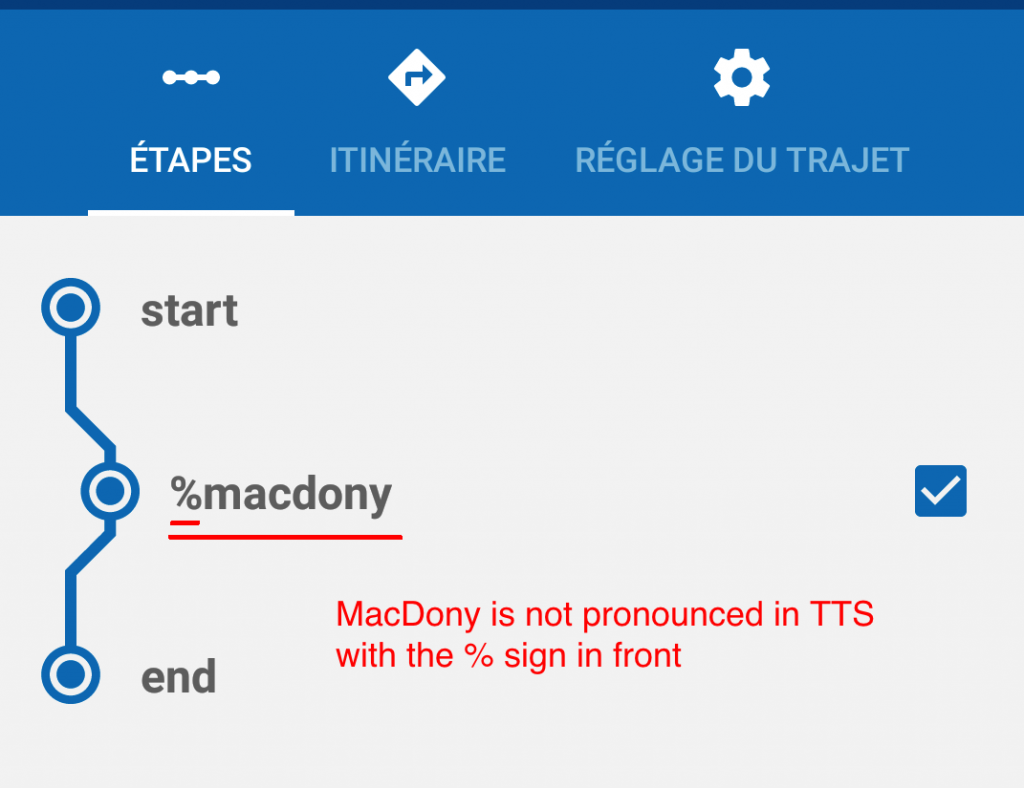
Hi,The % sign deactivates the entire sentence, regardless of its location.Examples:% my waypoint number 1my waypoint number 2 %my waypoint % number 3I have not yet found what to put to activate part of the sentence :-?
-
@MacDony - just thought to try my luck and get you to look at a couple of my issues - just jesting: -).
As for the "GPS position recording" I seem to have a unique problem. Please see my post https://forum.mapfactor.com/discussion/comment/18499#Comment_18499
Cannot understand it... -
Ok, in V5.5.103I don't see any problem to record in Gpx or Nmeabut save position does not work
-
@MacDonyLooking at the screenshots which one do you get. The one with the 2 options or the the one with the 3 options?How do the options behave on yours?At this moment I cannot save automatically in GPX format. When choosing the option "Save as GPX automatically" it saves in NMEA format instead.The option "Save as NMEA automatically" it behaves as the "Turn on/off manually" option which is the option that is missing on mine.I am trying to find out whether is something screwed up with my device or something is wrong with the app but I am not getting any response of any sort from the mapfactor team.
-
It looks like we mix up 2 different tasks into one thread...Could we sort out the recordings to another thread and go on with the "skip next waypoint" on MAP desk?Markus
Howdy, Stranger!
It looks like you're new here. If you want to get involved, click one of these buttons!
Categories
- All Discussions3,266
- Feature Requests1,276
- Bugs559
- General378
- Navigator FREE1,031
- Vehicle Tracking5
- Navigator 1017