Oh no!
-
What a routing (in Dresden)
 Why does Navigator not just stay on S 127?
-
28 Comments sorted by
-
with default car settings route is on S127please check your vehicle settings
-
+1 just for the title :-D
I know the issue too and I think it's caused by a too optimistic time calculation for turns plus the vehicle settings ("oh, we didn't use minor roads often enough to reach the desired percentage!") -
As we had it a couple of times, default settings are not really usable for daily life. It is way to fast especially in cities. And it is very tedious to move the slider to a specific speed. May be this is because of my small screen (Xperia Xcompact) in relation to my thick fingers :DFor me, it would be much more comfortable, to have an option to set speeds for calculation with a numeric pad.
-
"For me, it would be much more comfortable, to have an option to set speeds for calculation with a numeric pad."Full ACK
-
Speed AND Priority....
-
Possible reason for the detour: For MFN the S 172 (Zellescher Weg) is urban and the detour (Reichenbachstr.) is extra-urban. (In OSM both are tagged with urban.)
-
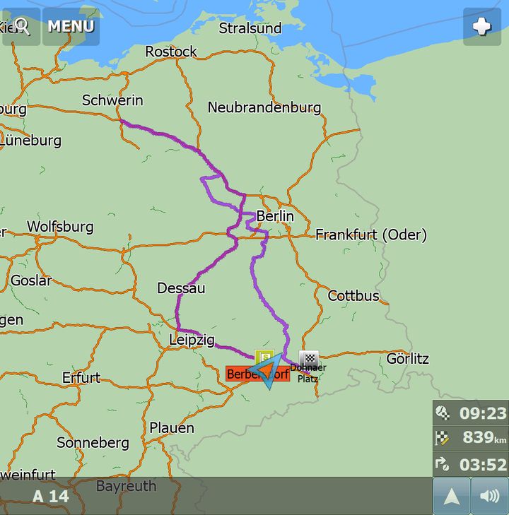
Another oh no!Some weeks ago, I was on my way from Chemnitz to Dresden, via the Autobahn A4. Since there was a traffic jam on the Autobahn (checked via Google Maps) some kilometers before Dresden, I wanted to leave the Autobahn early and therefore deselected Autobahn on the routing profile. The remaining distance was some 40 km. Look, what Navigator routed then:
 Absolutely crazy, nothing less like this. The first exit, actually some 10 km away, Navigator found, was North of Berlin, but on the "wrong" side of the Autobahn. So Navigator routed further North, turned back on an Autobahn intersection and left the Autobahn somewhere in the wild North of Berlin and routed back to Dresden on non-Autobahn roads. It it obvious, that I did not follow that. I selected then to use the Autobahn, and the routing became normal again, some 40 km left ...
 -
its all very well, but we need details to check, best in coordinates
-
Put the start on Autobahn A4 direction Dresden between exits Berbersdorf and Siebenlehn. Put target at Dresden South for example at Dohnaer Platz. Deselct Autobahn in routing profile. Start simulation. Have fun!
-
my primary route is 48km, 27minsecondary 45km, 30min
-
My result is like Oldie's:
Looks like at least Oldie, Matthias, Delfin and I have another program in use than you, tomas!
-
I have no idea how you achieve this - do you have the latest maps?
-
please provide departure and destination in coordinates, then I can test the same route
-
Hi Tomas,from 51.015833, 13.247778 to 51.008806, 13.785417I get the same result as Oldie and JambaFee.
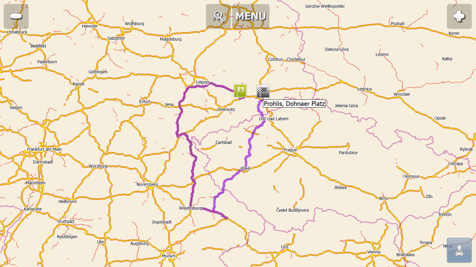
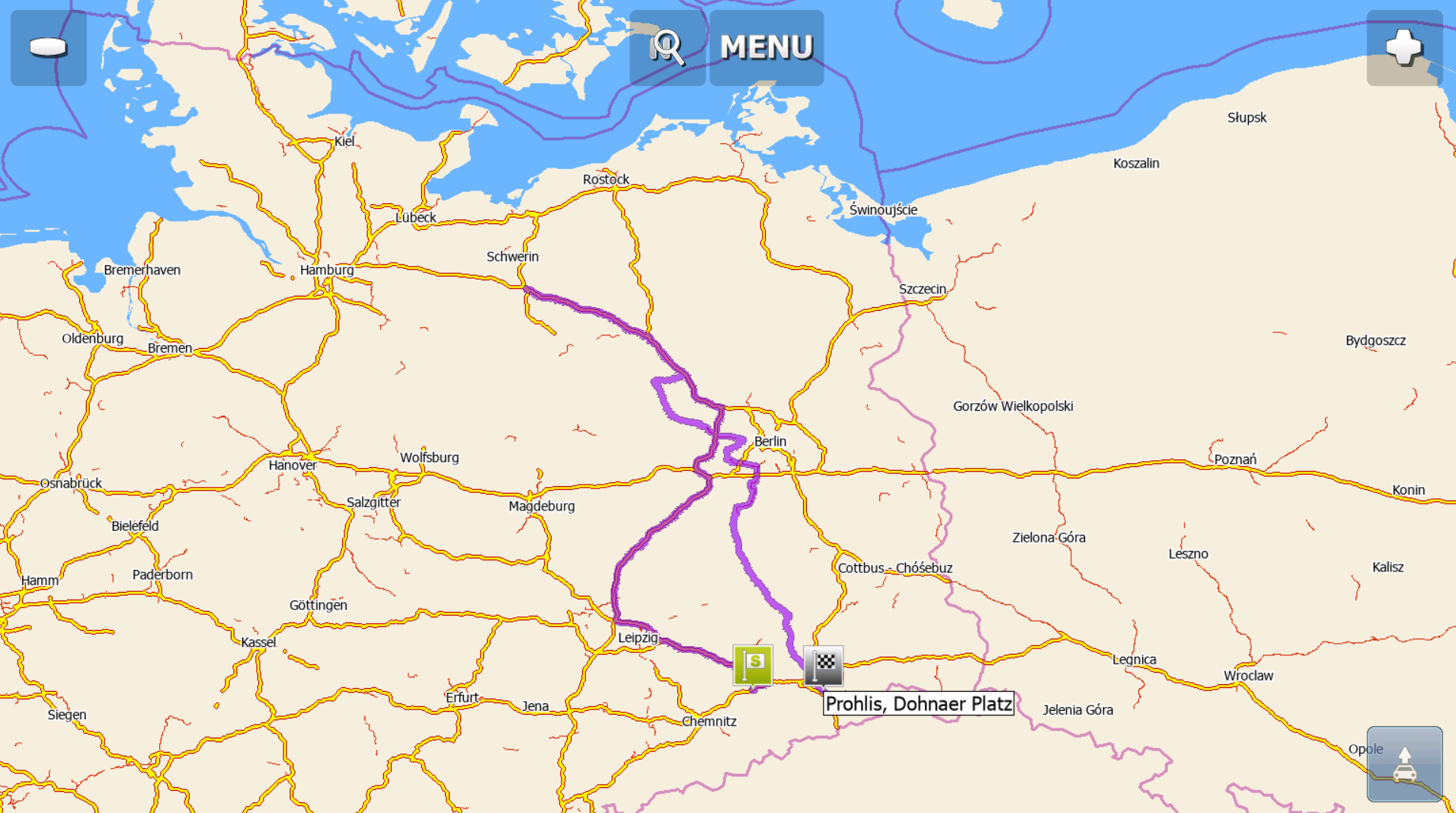 If the map of the Czech Republic is installed, I get the following routes (the first one if "Small Local Road" is disabled, the second one if "Small Local Road" is enabled).
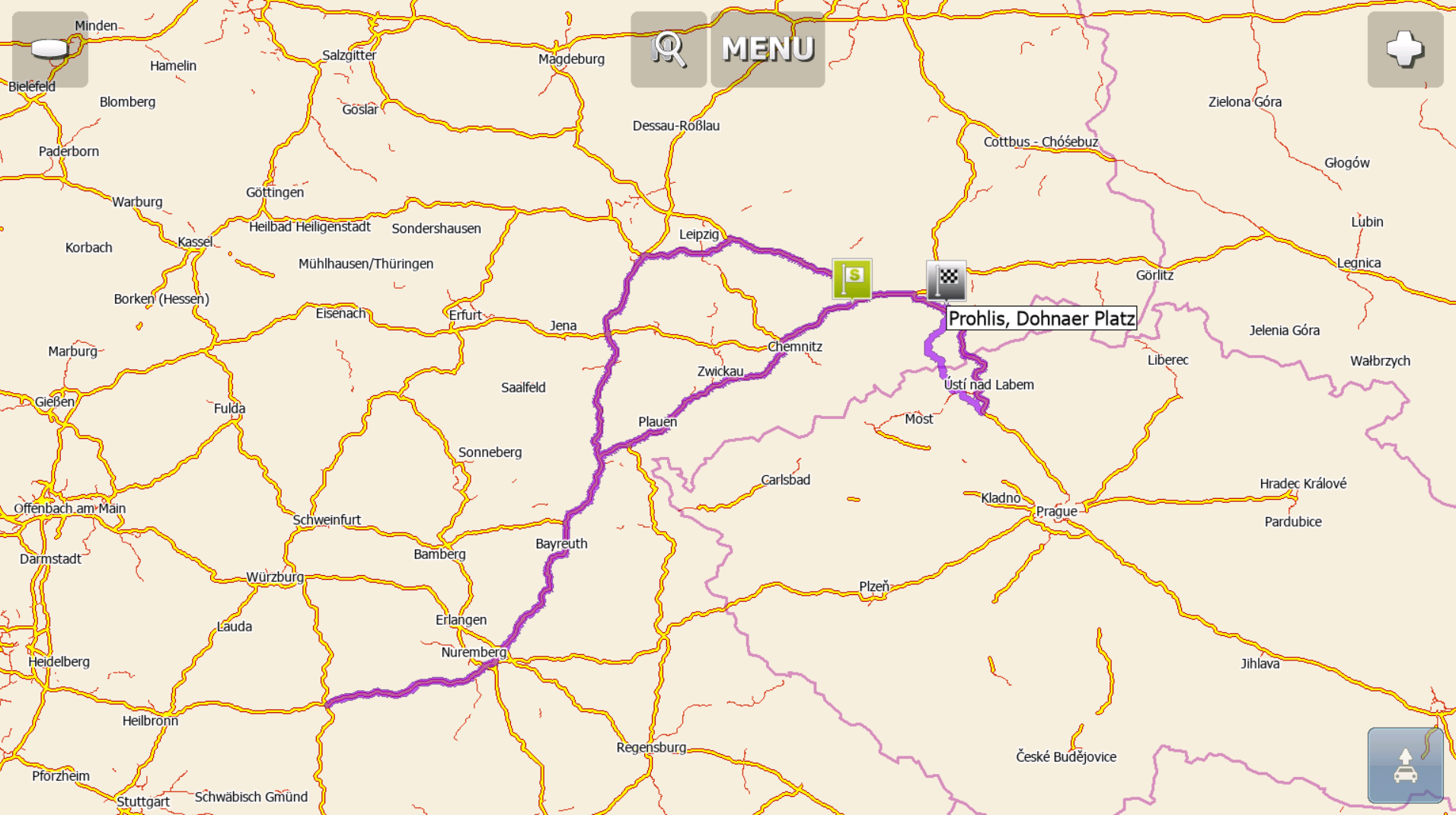
-
I have just updated maps, CZ Map is installed. Result as the latest image from @Delfin. Via Plzen, cheers!:))Checked on my Smartphone.
-
It is even much much more crazy. Start just before Siebenlehn exit on Autobahn A4. Target just behind on Bundesstraße B 101, some 3,5 km. Navigator does not use exit Siebenlehn, if you deselect Autobahn. It goes more than 800 km.
 This one tested after a map update on my tablet.If you are on Autobahn and deselect Autobahn in route profile, Navigator should simply leave the Autobahn at the next exit and stay on non Autobahn roads from there on.
-
Whell: MF is sending me over the wrong side of a highway!!!!530 14' 48.3'' N60 35'00.9"Eto530 14'34.1"N60 35'17.4"Esorry, can't insert picture
-
isn't that problem with your GPS?
-
( post above: first 0 should be the little thing means degrees)Even when I let MF calculate it on the PC it creates a route on the wrong side of the highway. Problem in OSM??? Could no see anything is wrong. Tryed some other points on our city-ring. When its shorter to drive on the wrong side, it will be calculated.
-
Thomas, I am pritty sure it's since the newest card-update, the older cards doesn't let me gost-driving!
-
Thomas,I send a e-mail with info.
-
Another oh no!A 14 in Germany just north of Dreieck Nossen direction Leipzig. Target was somewhere in Dresden. Switched off Autobahn in routing profile while navigating:
 Didn't follow this, just left the Autobahn at the (next) exit Nossen. Navigator automatically rerouted, made just 37 km from 800+.
 Followed this
:-)) -
Last friday I had another oh no. Mapfactor is still very week, when route options are set to no highway and you enter an highway anyway.I woul expect, that Mapfactor would try to leave the highway at the next opportunity, but it does not.Last friday I was heading the Bundesstraße 173 towards Dresden with my scooter, route options set to no highway.When I entered the Autobahn A 17 anyway direction south/Czech Republic Mapfactor route to somwhere behind the German/Czech Border and routed back north on the Autobahn (remember: highway option not set!!!).This is simply crazy!
-
Again last Friday. I am on Autobahn 4 from Chemnitz to Dresden.I want to check, how much time it takes to arrive and start navigation to Herschelstraße Dresden, a distance of approx 50 km. Routing is Leipzig, Nürnberg Passau, "U-turn" on Autobahn, Pilsen, Dresden 846 km.I found, that route setting was still set to no Autobahn (from a previous route calculation). But nevertheless Navigator routed more than 400 km over different Autobahns. The next exit was just 10 km away ...
-
please provide departure and destination in coordinates
-
You don't need coordinates. The result is just the same as in the third image from Delfin from August 2019, see above. Just set the points as I described in my last post.
-
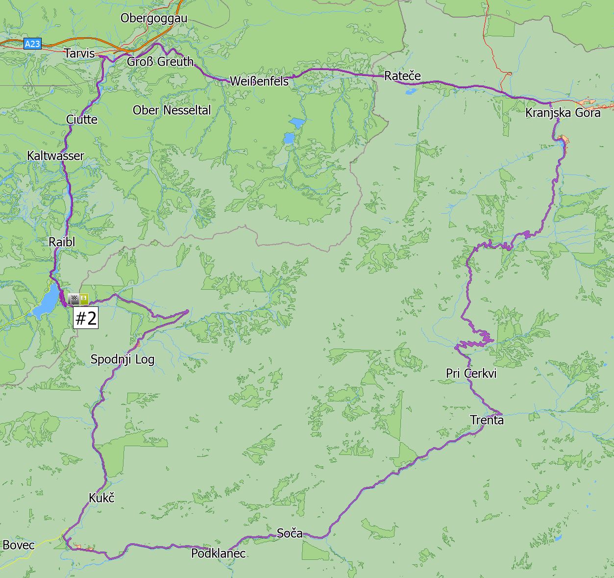
Does anyone have an explanation for this routing:
From 46.4189383650124 13.5798162587066 (Slovenia)
To 46.4190288989523 13.5757910957773 (Italy)
Instead of crossing the border from Slovenia to Italy which is about 350 m MFN takes a route of 87 km. It does it in the PC version as well as on Android.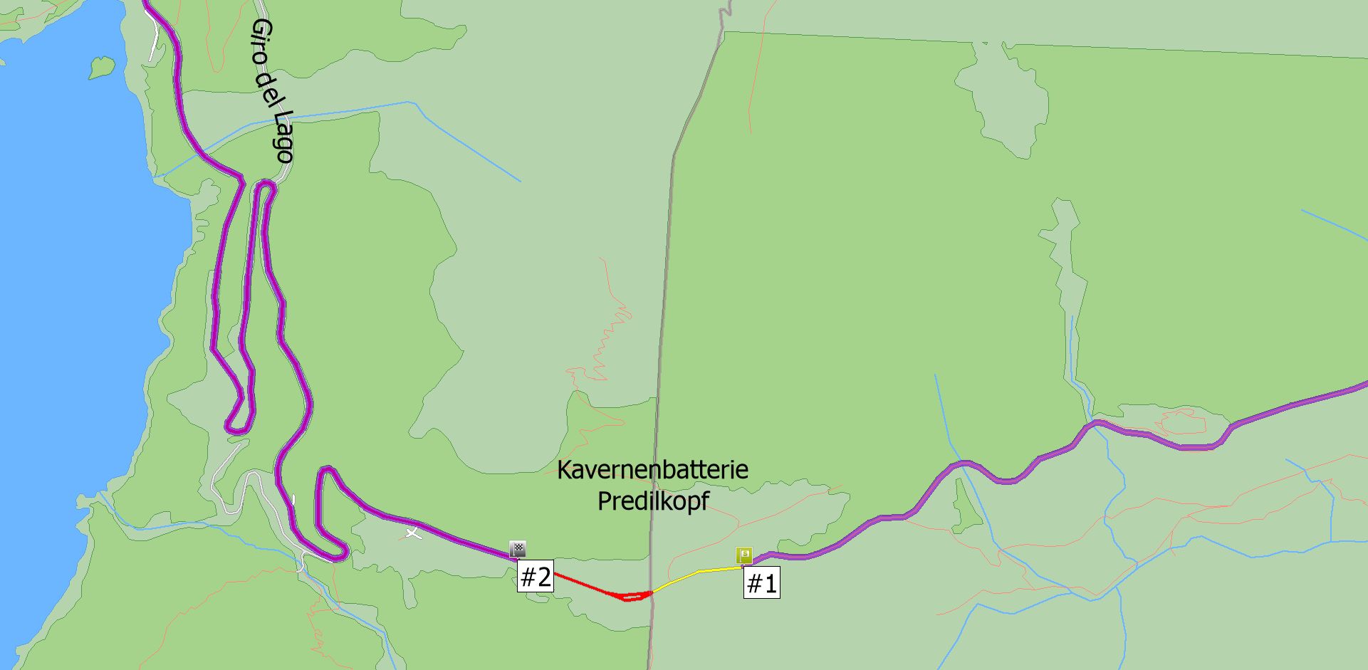
 Can it have to do with the fact that the italian map is more than eight month old?
 -
Map is from Nov. 15, 2020That border section/node has been edited in openstreetmaps on Jan. 22, 2021 - guess alessandrocarmeli found the bug more than six months ago ...Regards ...
Howdy, Stranger!
It looks like you're new here. If you want to get involved, click one of these buttons!
Categories
- All Discussions3,266
- Feature Requests1,276
- Bugs559
- General378
- Navigator FREE1,031
- Vehicle Tracking5
- Navigator 1017
In this Discussion
- chattiewoman August 2019
- Delfin August 2019
- JambaFee July 2021
- MB76 August 2019
- Oldie August 2020
- Pidie August 2019
- RogerGatsky August 2021
- tomas August 2020