Speeds used by MFN higher than speed limits
-
Why are the speeds used by MFN for the calculation of the itinerary and the estimated time to destination higher than the speed limits (maxspeed tag in OSM)?
10 km/h --> 15 km/h
20 km/h --> 45 km/h
30 km/h --> 45 km/h
40 km/h --> 45 km/h
50 km/h --> 55 km/h
60 km/h --> 65 km/h
70 km/h --> 95 km/h
80 km/h --> 95 km/h
90 km/h --> 95 km/h
100 km/h --> 115 km/h
110 km/h --> 115 km/h
120 km/h --> 130 km/h
This leads to suboptimal routing and too low estimated time to destination.
-
30 Comments sorted by
-
Mapfactor uses your setup and the numbers provided there.
More intelligent would be using your car speed.
-
@ Gaspar: No! An example: On a motorway with 130 km/h in the setup, MFN uses 95 km/h when the speed limit (maxspeed tag in OSM) is 80 km/h.
-
please give coordinates
FYI, you can choose to use/not use speed limits in road restrictions
-
Thanks Tomas.
From 48:33:50.1, 9:40:26.9 to 48:34:31.3, 9:40:32.6 with default car profile ("Use speed limits" still set):
Speed limit is 80 km/h, MFN uses 95 km/h.
-
what makes you think that MFN uses 95km/h?
if simulation, then this does not indicate anything
-
Simulation is not real time?
-
simulation is using average speeds to make it 'more realistic' :-)
-
Please calculate and simulate the following route with default car profile ("Use speed limits" enabled). On the whole distance of 4 km there is a speed limit of 80 km/h (tagged in OSM).
From 48:41:42.9, 9:24:11.3 to 48:40:24.5, 9:21:46.8
The time to destination calculated by MFN is 00:02:39 h. This corresponds to a speed of 90 km/h !
-
From Longmans dictionary: "the activity of producing conditions which are similar to real ones, especially in order to test something, or the conditions that are produced"From Longmans business dictionary: "an activity or situation that produces conditions which are not real, but have the appearance of being real, used especially for testing something"Like Tomas mentioned: It is only simulation. And of course a simulation is always faster than a real-time experience.As an example: Do you expect the simulation to make you also wait for traffic lights (say an average 30%) during simulation, or making you "give way" for traffic coming from the right side, also taking some time? And occasionally produce an accident putting you in a half hour traffic jam?Because that might make your experience more "real time".The simulation is meant to show your route, or test your route. I have used and tested many navigation apps. Not one single app gives you a "real time, real world" reproduction. Some even simply go at a 480 km/hr over an 80 km road. Others (like MNF) give you the option to speed up the simulation to 2x, 6x or whatever (where 6x might even be 6,2X if you test it).It is simply to show you your route.Not that if it predicts an ETA of 3 hours 40 minutes, I don't expect you to sit and wait if it really simulates 3 hours and 40 minutes (or do you?)Note also that some apps do not even give you the option to simulate.
-
Indifferently whether calculation or simulation or navigation MFN has a problem with the speed limits !
90 km/h or even higher up to 95 km/h on a road with a speed limit of 80 km/h ???
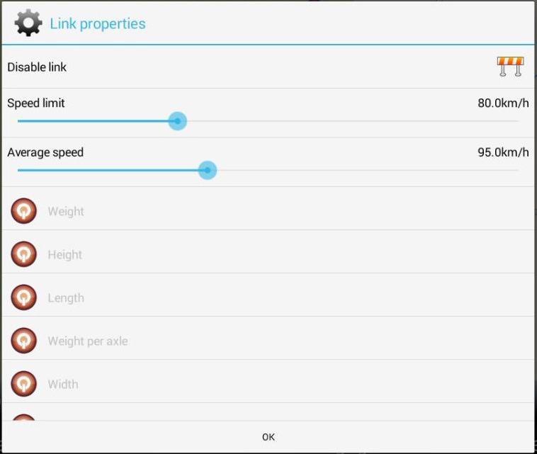
BTW, the speeds used by MFN for calculation, simulation and navigation can be seen in the link properties (pencil icon).
-
What Delfin means with his example is: For the distance of 4 km at a constant speed of 80 km/h (that's the limit oft he whole route) you need exactly 3 minutes. If you drive the route in 00:02:39 as MFN calculates then your speed is 90,57 km/h and that’s too fast.
A navigation program must NEVER calculate with a higher speed than allowed. And the mentioned parameters you see when pressing the pencil-icon on the route shows that MFN is aware of the limit of 80 km/h but uses an average speed of 90 km/h. That has nothing to do with simulation, that’s IMHO simply an error.
-
An example of how it should be: MFN calculates the route from 48°17'00.8"N 14°18'33.0"E to 48°18'51.5"N 14°18'25.4"E (4.0 km motorway) in exactly 00:03:00. The parameters (pencil-icon) used by MFN are speedlimit 80 and average speed 80.
I don't see any errors in OSM-tagging so I can't explain that different behaviour of MFN.
-
Thank you JambaFee. What you say is exactly what I mean. Just one thing: If you calculate a route before using the pencil icon you'll see speed limit 80 km/h and average speed 90 km/h in the parameters in this case.
Some other examples:
- On a road with 50 km/h in the settings and a tagged speed limit of 30 km/h MFN uses 45 km/h.
- On a road with 130 km/h in the settings and a tagged speed limit of 80 km/h MFN uses 95 km/h.
- On a road with 130 km/h in the settings and a tagged speed limit of 100 km/h MFN uses 115 km/h. -
-
@chattiewoman
"Use speed limits" is actually used but not as it should be:
Example: Road with 130 km/h in the settings and a tagged speed limit of 100 km/h:
"Use speed limits" disabled --> 130 km/h (correct)
"Use speed limits" enabled --> 115 km/h instead of 100 km/h
Where do these 115 km/h and the other crazy speeds (see beginning of discussion) come from ?
-
@Delfin and @JambaFee: Sorry. You are right. But not in all cases. I tried Delfins example and MNF calculates an incorrect ETA. It is using too high speeds. When using Mapzen and Graphopper they calculate correct travelling times.However, I used it also on another 12 km trajectory where the speed is 80 km/hr on the whole trajectory. The estimated travel time was 10 minutes, which is correct. And so did Mapzen and Graphhopper: They calculated the same distance and same travel time.Somehow there is something inconsistent in MNFs calculations.
-
-
52.486716, 6.171943 to 52.401504, 6.266270 are the cordinates. It is a track on the "Heinoseweg"
-
Don't know why all the fuss. You cannot simulate a real time journey, there are far too many variables and I am not even sure why you would want to, it all seems to be pointless. You get an 'estimated' time of arrival and that for me is good enough and all you can expect from a simulation.
-
@ hvdwolf
In your example, MFN uses a speed that corresponds to the speed limit of 80 km/h. This is not because MFN respects the speed limit, but because the speed setting for this road type (secondary road in MFN) is 80 km/h. If you increase the setting to 90 km/h, MFN will use 90 km/h, if you increase to 95 km/h or higher, MFN will use 95 km/h.
-
@Roldorf I think, the issue meanwhile is not only simulation but route calculation as well. This should at least be as realistic as possible but it is not, if (if!) MFN uses speeds, that are not allowed.
-
@Delfin: As far as I can check, your road example has a speed tagging of 80 KM/hr, but MNF uses the 100 km/hr setting as internally defined for the type of road? It doesn't look at the setting "Use speed restrictions" for that specific profile parameter? Is that what you mean?@Roldorf: Oldie is right. That was also my misunderstanding. It has nothing to do with simulation.If you calculate a route, MNF almost always calculates a travelling time, and therefore an ETA, that is not correct. It uses too high speeds for the calculation of the route. If you calculate a route, and do that in multiple OSM planners like MNF, Graphhopper, Mapzen, MagicEarth, OsmAnd, etc., MNF often (not always) comes up with a too short travelling time whereas the others have roughly the same ETA.Note that on longer distances like Amsterdam - Paris etc. , all the planners start to deviate. It is on the shorter distances.
-
@hvdwolf
If "Use speed limits" is disabled, MFN uses the speed set in the car profile.
If "Use speed limits" is enabled and a speed limit is tagged in OSM (maxspeed), MFN is aware of the speed limit but uses the following speeds for route calculation, simulation and navigation:
Speed limit Speed used by MFN
10 km/h min {15 km/h, speed in car profile}
20 km/h min {45 km/h, speed in car profile}
30 km/h min {45 km/h, speed in car profile}
40 km/h min {45 km/h, speed in car profile}
50 km/h min {55 km/h, speed in car profile}
60 km/h min {65 km/h, speed in car profile}
70 km/h min {95 km/h, speed in car profile}
80 km/h min {95 km/h, speed in car profile}
90 km/h min {95 km/h, speed in car profile}
100 km/h min {115 km/h, speed in car profile}
110 km/h min {115 km/h, speed in car profile}
120 km/h min {130 km/h, speed in car profile}
min {x, y} means minimum of x and y
Examples:
Motorway with a speed setting of 130 km/h in the car profile, speed limit 100 km/h
--> speed used by MFN = min {115 km/h, 130 km/h} = 115 km/h
Primary road (MFN) with a speed setting of 90 km/h in the car profile, speed limit 80 km/h (as in my example)
--> speed used by MFN = min {95 km/h, 90 km/h} = 90 km/h
Secondary road (MFN) with a speed setting of 80 km/h in the car profile, speed limit 80 km/h (as in your example)
--> speed used by MFN = min {95 km/h, 80 km/h} = 80 km/h
-
You did take into account the Maximum speed threshold (Max. snelheid drempel) setting?
Found in Navigation: Advanced: under speed and camera alerts:
Maximum speed threshold (tap on)
mode selectable (tap on to change):
- Percentage
O 5% over speed limiet
O 10% over speed limiet
O 15% over speed limiet
- Exact speed Limit (Exacte snelheids limiet) <= my guess select this option
- Value (waarde)
what should account for the difference found in calculation
-
@Jan_Gruuthuse: The setting you have suggested only affects the speed warnings, not the speeds used by MFN to calculate the ETA.
-
If you say so, had no time to test this.
-
When will Mapfactor finally correct the incorrect consideration of speed limits?
MFN drives on the Boulevard Périphérique of Paris with an average speed of 95 km/h (35 km in 22 min 6 s). Only 70 km/h are allowed (and tagged in OSM) on the entire route.
-
I have found that setting my maximum speed limit to 110 kph on motorways and so on down the list gives me a fairly accurate time of arrival when actually driving. In any case I don't like driving any quicker that that.
-
I think the bigger problem than a wrong ETA is that because of the internally wrong calculated travelling time (too short in the above mentioned cases) it is possible that MFN doesn't choose the correct fastest route (given that your optimisation mode is "fastest").
In fact I don't see any reason what this miscalculation could be good for, in my opinion it is a bug.
Howdy, Stranger!
It looks like you're new here. If you want to get involved, click one of these buttons!
Categories
- All Discussions3,266
- Feature Requests1,276
- Bugs559
- General378
- Navigator FREE1,031
- Vehicle Tracking5
- Navigator 1017
In this Discussion
- chattiewoman September 2017
- Delfin August 2019
- Gaspar September 2017
- hvdwolf September 2017
- JambaFee August 2019
- Jan_Gruuthuse September 2017
- Oldie September 2017
- Roldorf August 2019
- tomas September 2017