error on gps altitude
-
in the "tools / gps info" section, the altitude is systematically over-evaluated. The displayed value exceeds the actual altitude by 50m, that given by IGN maps, or by other gps.
I am running Android 9, but the problem was already there under earlier versions.
-
6 Comments sorted by
-
altitude comes from Android, presumably they do not use altitude correction
-
Android never does altitude correction!The GPS altitude from android is simply the altitude above the WGS84 reference ellipsoid as given by the satellites. It is not the real altitude above ground level or sea level.The app using the GPS data should take care of the correction like multiple apps do. Based on Tomas' answer you can conclude that Navigator doesn't do that (some do, some don't).There are several online calculators who can (theoretically) calculate the height for that "geoid": The GPS height plus/minus the "geoid" (geographical) height = the "real" height.Depending on the accuracy and fine detail of the used geo-height database behind it, you get a better value. But if they have a geoid location every kilometer (for example), you still don't get good accuracy in hilly or mountainous areas.So if Navigator gives 87 meters, and another app gives an "altitude corrected" height of 48 meters, both could still be wrong. It is only an indication when travelling from the sea in the Netherlands to the Matterhorn in Switzerland.Concluding: Your "exceeds the actual altitude by 50 m, that given by IGN maps" could be right, but just as well wrong. Statistically when travelling all over the world, your corrected app should do better. But, based on a few measurements without(!) a real good correct reference, it means absolutely nothing.Since I know this I hardly spend detail to the altitude, unless I am in a really big flat area.Finally, and in addition to above: cheap GPS receivers in cheap phones mostly handle altitude really bad giving an extra deviation to the real altitude.
-
How about relative altitude? If Navigator gives at place A an altitude of 100m and an altitude of 300m for place B, can I assume, that at least the difference is truely 200m?
-
It depends on where the locations A and B are. Depending on the geoid undulations at the locations, the actual height differences (above the geoid) can be between 11 m and 389 m.
-
wrong answer. deleted.Please search for WGS84 (WGS 84), geoid, altitude(oder WGS84 (WGS 84) geoid, höhe)It is not about relative altitude. It is about the "deviations" in the WGS84 model. The links will tell you more.This link (English) is quite explanatory (I think): https://gisgeography.com/wgs84-world-geodetic-system/But the last line in that article "The error of WGS84 is believed to be less than 2 centimeters to the center mass." I do not understand. Then why do we still need "altitude correction"?
-
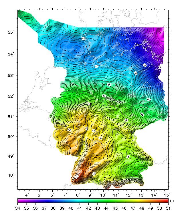
@hvdwolf: The 2 cm is about the accuracy of the geoid. What you call "altitude correction" is about converting the altitude indicated by Navigator (= altitude above the ellipsoid) to the corresponding altitude above the mean sea level (= altitude above the geoid).To do the conversion subtract the so-called geoid undulation from the altitude displayed by Navigator. The geoid undulation depends on the location and is between +83 m and -106 m.In Germany, the geoid undulation is between +34 m and +51 m.
Howdy, Stranger!
It looks like you're new here. If you want to get involved, click one of these buttons!
Categories
- All Discussions3,266
- Feature Requests1,276
- Bugs559
- General378
- Navigator FREE1,031
- Vehicle Tracking5
- Navigator 1017